Technology

TROPICAL STROM ERIKA IS CENTERED IN THE EASTERN CARRIBEAN SEA

ACCORDING TO NASA


Logo NASA (Source: NASA)
NASA's Terra satellite saw Tropical Storm Erika
(Source: Courtesy of NASA Goddard MODIS Rapid Response Team)
USPA NEWS - Tropical Storm Erika was centered in the Eastern Caribbean Sea and affecting Puerto Rico and Hispaniola when NASA's Terra satellite passed overhead mid-day on Friday, August 28, 2015. Two hours after Terra passed, NOAA's GOES-East satellite saw Erika's western side over the Dominican Republic. 
AIRS instrument aboard NASA's Aqua satellite
Source: Courtesy of NASA/JPL, Ed Olsen
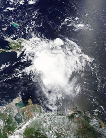
"Just two hours later NOAA's GOES-East satellite captured a visible image of Erika and showed that the storm had already covered the Dominican Republic on its west-northwestern track. Tropical Storm Erika was centered in the Eastern Caribbean Sea and affecting Puerto Rico and Hispaniola when NASA's Terra satellite passed overhead mid-day on Friday, August 28, 2015. Two hours after Terra passed, NOAA's GOES-East satellite saw Erika's western side over the Dominican Republic.  At 15:05 UTC (11:05 a.m. EDT) the Moderate Resolution Imaging Spectroradiometer instrument aboard NASA's Terra satellite captured a visible light image Tropical Storm Erika approaching Hispaniola. Erika's center was in the eastern Caribbean Sea, and the northern quadrant of the storm blanketed Puerto Rico with clouds and showers. 
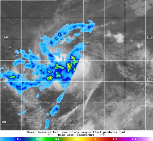
The photo describes : On Aug. 25 at 01:59 UTC, the AIRS instrument aboard NASA's Aqua satellite saw cloud tops around Erika's center were near -63F/-53C, indicating strong thunderstorms." NASA's team WATCHES AND WARNINGS STILL EFFECT FOR THE EASTERN CARIBBEAN AND BAHAMAS----------------------- "At 2 p.m. EDT, there were a number of watches and warnings still in effect for the Eastern Caribbean and the Bahamas. A Tropical Storm Warning was in effect for the Dominican Republic, Haiti, southeastern Bahamas, Turks and Caicos Islands, and the central Bahamas. A Tropical Storm Watch was in effect for the northwestern Bahamas, the Cuban Provinces of Ciego de Avila, Camaguey, Las Tunas, Holguin, and Guantanamo.Heavy rainfall is a large threat from Erika. Erika is expected to produce total rainfall accumulations of 3 to 6 inches with maximum amounts of 10 inches possible across portions of the Dominican Republic and Haiti, the Turks and Caicos Islands, and the southeastern and central Bahamas through Saturday. An additional 1 to 2 inches is expected for Puerto Rico.  These rains could cause life-threatening flash floods and mud slides." NASA's team
Erika Storm capture comprehensive data Satellite
Source: Courtesy of NASA
ERIKA ON AUGUST 28, 2015 at 2PM EDT------------------------------------------------------At 2 p.m. EDT (1800 UTC) on August 28, 2015, the center of Tropical Storm Erika was located near latitude 17.7 North, longitude 70.2 West. Punta Cana at the eastern end of the Dominican Republic reported wind gusts of 40 mph (64 kph). Erika has been moving westward near 18 mph (30 km/h) for the past several hours.  A motion toward the west-northwest is expected to being later this afternoon or tonight and continue through Sunday, August 30.  On the forecast track, the center of Erika will move near the Turks and Caicos Islands on Friday night, August 28 and move near the central and northwestern Bahamas on August 29. Maximum sustained winds are near 50 mph (85 kph) and some weakening is forecast from the National Hurricane Center as Erika moves over land. The minimum central pressure based on Hurricane Hunter aircraft data and surface observations is 1009 millibars. The photo describes : Satellites analyze tropical storm Erika as it moves west, and capture comprehensive data, inside & out. The storm is expected to approach the Leeward Islands Wednesday night.
NASA Satellite
Source: Courtesy of NASA
FACTORS TO CONSIDER IN ERIKA´S FATE ----------"The NHC is closely monitoring the storm and adjusting the forecast track as needed. There are a number of factors that are being considered in the National Hurricane Center (NHC) forecast. NHC Forecaster Beven noted in the Aug. 28 NHC discussion at 2 p.m. EDT, "Westerly to southwesterly vertical wind shear is forecast to continue or increase during the next 12 to 24 hours. This, combined with land interaction, suggests that the cyclone should weaken, and there is a chance the system could degenerate to a tropical wave while crossing Hispaniola. Assuming the cyclone survives, the shear should decrease some after 36 hours, which could allow some strengthening up to the time of possible landfall on the Florida Peninsula."As of 2 p.m. EDT on August 28, the NHC five day forecast track takes Erika on a track northwest and paralleling the north coast of Cuba before making landfall in southwestern Florida early Monday, August 31. Source: NASA
Liability for this article lies with the author, who also holds the copyright. Editorial content from USPA may be quoted on other websites as long as the quote comprises no more than 5% of the entire text, is marked as such and the source is named (via hyperlink).